Floor 3: Ojai, Malibu, Anacapa Island Landmark Paintings
Coming out of the elevators, and starting to your left, we will begin with Foster Park.
Foster Park Lion Entrance Markers.
The majestic sandstone lions sit atop 10-foot-high pillars, on either side of Casitas Vista Road at the east end of Foster Park Bridge. The north lion dedication was in 1907, to E P Foster and his wife; the south lion marker was dedicated in 1908, to Eugene, their son, who died at age six. E P Foster helped establish several parks in the County. Over the years, the markers have been worn due to weather and vandalism.
Acacia Mansion.
This Spanish Colonial Revival style house with Moorish influences was designed and built by John Roine in 1929. Mr. Roine was a native of Finland who hired artisans from his native land to do much of the work. The residence was built for the Bairds from Newfoundland, who made their fortune in the Canadian fishing industry. Mr. and Ms. Baird came to the Ojai Valley as followers of the Theosophical Society, which in 1924 had established the Ojai Valley Krotona Institute of Theosophy, which still remains.
Libbey Park Bowl Sycamore Tree.
Chumash Native Americans were said to have bent the sapling tree to mark the beginning of an important trail, or a fine camping spot. The top rooted to form an arch, which was known to the Chumash as the Peace Tree, or Marriage Tree. As a marriage tree, they believed that two lovers walking together through the arch, are united by the Great Spirit....
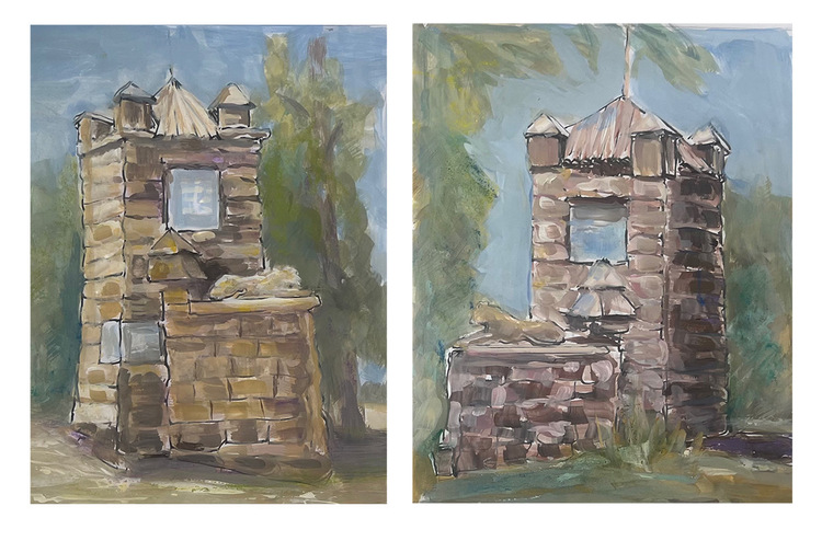
County Fire Station Number 21.
The concrete brick one and two-story fire station building was constructed with funds from the Depression-era Works Progress Administration in 1936. It housed two fire trucks, a dormitory, storage, and living quarters for the County Fire Warden and family. Now home to the Ojai Vineyard tasting room.
Ojai Post Office Tower and Portico.
This landmark structure, designed in 1916 by Architects Mead and Requa, was a gift to the City of Ojai from Edward Libbey. The tower, featured on the city's official seal, is three stories high with a domed top inlaid with Spanish tile. Inside, wooden stairs lead to top of tower where electric chimes have been installed.
Artist Teresa Griffin won the award “Essence of Ojai,” for Libbey Post Office Tower and Portico, the most iconic landmark in Ojai. Her fearless color choices evoke the drama of Ojai’s pink moment.
The next two watercolor paintings are of the Saint Thomas Aquinas Chapel,
Which is listed on the National Register of Historic Places.
Saint Thomas Aquinas Chapel is a former Catholic chapel located in the City of Ojai. It now houses the city's museum, research library, and historical society. In 1918 the chapel was designed by regionally renowned San Diego architects Richard Requa and Frank Mead in the Mission Revival style, with Spanish Colonial influences, to replace Ojai's original wooden Catholic church that had been destroyed by fire.
The tour continues around the corner, with three paintings of Nye Ranch, (now known as Birdsong Ranch).
Today’s Birdsong Ranch owners are focusing the restoration of the historic Nye ranch property to create a habitat for native birds, and increase biodiversity and beauty using native plants. The property consists of over 123 acres of primarily open space, and an American Colonial Revival-style house built in 1918. The property is significant for its direct association with settlement and development in the Casitas Springs area, and its continued use as an agricultural and ranching property through the late 1950s. The Nye family owned the property for 96 years. In the late 1950s, Orville Nye subdivided a portion of the property to create a residential development in Casitas Springs.
Bell Canyon Equestrian Center.
Listed in the National Register of Historic Places.
Bell Canyon, affectionately dubbed the “Bel Air of the San Fernando Valley,” was developed in 1968 in southeastern Ventura County, and is home to the Bell Canyon Equestrian Center, a 10 acre facility. Designed by renowned architect Cliff May, who is celebrated for pioneering the low‑slung, pitched‑roof California Ranch‑style home and influential Mid‑Century Modern designs, the center retains remarkable integrity of workmanship. It features hallmark May elements such as stucco walls, an arched breezeway, a cylindrical tower, and a landscaped central courtyard, along with one main building, four stable barns, three riding arenas, spacious turnouts, a round pen, wash racks, and multiple cross‑tie areas for horse grooming.
The next 5 paintings were painted at the Tony Duquette historic site.
Tony Duquette Historic District, now known as (Xanabu).
Located in the hills of Malibu yet still in Ventura county, and today known as Xanabu, the Tony Duquette Historic District focused upon the creations of nationally significant artist and designer Anthony “Tony” Duquette, who lived from 1914 to 1999. Duquette's work within the district showcases his signature use of found and repurposed materials, reminiscent of “art environments,” like Watts Towers in Los Angeles, and Bottle Village in Simi Valley. He incorporated diverse elements such as scrap metal, surplus materials from military and Hollywood backlots, satellite dishes, fiberglass components, and succulents rescued from Chavez Ravine in Los Angeles (to make way for Dodger Stadium). These materials, combined with salvaged movie set pieces, like from The 1959 movie Gazebo, illustrate his ability to transform discarded objects into cohesive and enchanting designs, including larger structures, such as a horse stables complex, triple pagoda, birdcage pavilion, and gazebos, along with smaller elements, such as sculptures, miscellaneous art objects, and flag masts. It is not open to the public.
Artist Lisa Sachs won the award “Colorful Renderer,” for her painting of Xanabu in Malibu. She has a unique style of layering pastel on top of watercolor while painting onsite, and sometimes even adding collage later in the studio.
Continue further to see two more paintings on this floor.
Mugu Rock.
Point Mugu Recreation Area and State Park contains numerous archaeological sites indicating the presence of a major Chumash village in the La Jolla Valley, and includes the largest remaining natural grassland in California. The name “Mugu,” comes from the Chumash word “muwu,” meaning “beach.” The area was inhabited by the Chumash for more than 6,000 years, until the 1850s. Mugu Rock, a prominent landmark, was formed when the Pacific Coast Highway was constructed between October 1937 and February 1940 by cutting through the mountain; prior to the highway’s construction, a road circled around the rock along what is now a fenced-off area to keep visitors away from the hazardous shoreline.
Anacapa Island Archeological District.
Listed in the National Register of Historic Places.
For thousands of years, the Chumash people visited Anacapa Island, known to them as “Anyapakh,” meaning “mirage.” European fishermen and sheep ranchers arrived in the 1800s, and in 1932 the Coast Guard built the last permanent light station on the West Coast on the island. Protection began in 1938 when Anacapa Island, along with Santa Barbara Island, was designated a national monument, and in 1980 it became part of Channel Islands National Park. Today, the surrounding waters are managed by the National Park Service, the Channel Islands National Marine Sanctuary, and the State of California. Located 12 miles offshore, Anacapa Island is a five‑mile‑long volcanic landform divided into three islets—East, Middle, and West—sculpted by waves into dramatic cliffs, sea caves, and natural bridges, including the iconic 40‑foot‑high Arch Rock. The island provides critical habitat for endemic plants and animals, pinnipeds, and seabirds, including the largest California brown pelican rookery in the United States.
The tour continues on the top floor. Take elevator to Floor 4, to see Port Hueneme, Oxnard, Santa Paula, Ventura, and Moorpark landmark paintings.
-
Welcome to the Atrium Gallery
-
Floor 2 (Main Plaza Level): Simi Valley and Fillmore Landmark Paintings
-
Floor 2 (Main Plaza Level): Thousand Oaks and Camarillo Landmark Paintings
-
Floor 3: Ojai, Malibu, Anacapa Island Landmark Paintings
-
Floor 4: Port Hueneme and Oxnard Landmark Paintings
-
Floor 4: Santa Paula Landmark Paintings
-
Floor 4: Ventura and Moorpark Landmark Painitngs