Exploring Contours
You now have a good insight on map orientation, distance measurement, identifying features and contour lines. These things need loads of practice to really understand, but we have sewn the seed and you will now be developing skills, now you know more about how to interpret the map.
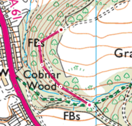
We're going to take the main path to the right that contours (stays relatively level) through the woods for 500m to try to find a little path junction - see if you can work out how long this may take. Also if you look closely at the map you will stay in the woods and relatively flat for the first section, then as the path bends round the corner, you start to cross some contours, this means that you can expect to gain some height as you walk up hill more steeply before seeing a path on your right.
Stop at the path junction in 500 metres
-
Fort St James
-
1. Bienvenue
-
2. Mât
-
3. Entrepôt Général et Magasin de Fourrures
-
4. Cache à Poisson
-
5. Maison des Employès
-
7. Jardin
-
8. Magasin
-
6. La Maison de l'Interprète
-
9. A) Résidence de l'officier
-
9. B) Résidence de l'officier