Introducing Contours
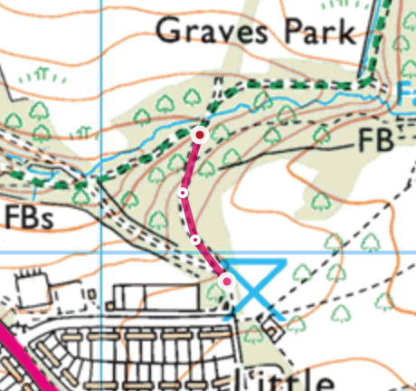
From the bottom of the car park, orientate your map so that it is rotated in a way that shows two paths going into the woods in front of you. The path to the right stays flat, whislt the path on the left goes downhill.
You can start to see that height gain and loss is represented with contour lines, which are the orange/brown lines on the map. These lines reperesnt areas that are the same height. s you cans ee the path on the left crosses many contour lines, meaning that in this instance the path is descending. The path on the right goes alongside a contour line, effectively meaning that it is staying level, as you can see as the path goe towards the river, it crosses several contour lines, meaning that the track will descend down towards the stream.
By looking at the contours, you can get an idea about what the terrain is going to look like before you walk along a particular path.
Now take the right hand path that goes into the woods and descends down to the stream, stop when you get to the stream - though note that it is quite subtle. It's worth thinking about what happens to the path if you walk past the stream, this is called an overshoot feature - as you can see on the map, the path would go round to the right and actually start to go uphill again.
-
Fort St James
-
1. Bienvenue
-
2. Mât
-
3. Entrepôt Général et Magasin de Fourrures
-
4. Cache à Poisson
-
5. Maison des Employès
-
7. Jardin
-
8. Magasin
-
6. La Maison de l'Interprète
-
9. A) Résidence de l'officier
-
9. B) Résidence de l'officier