How far have I gone?
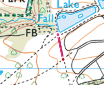
You now need to keep your map orientated, so rotate your phone to represent the different paths that you can see on the ground. The red line marked on the map is the path that we are going to take and is the only path heading uphill from here.
In this lesson, we're going to see why measuring distance is important.
All maps have a scale, this map has a scale called 1:25,000. Which means that 1cm on the map represents 25,000 cm on the ground. Which can be translated to 1cm on the map, representing 250m on the ground. So if you had a method of measuring a map, such as a ruler or a roma scale (found on a compass) you could easily measure how far you are walking.
We have measured the next section, it's 100m in total. A really handy tip for knowing how far you have walked is to conside how long it takes. People tend to walk naturally between 4 kilometers and 5 kilometers per hour, which equates to around 12 to 15 minutes per km.
Try timing how long this section takes you (the stopwatch on your device or a watch is handy). We'll look at what this means when we get to the next stop.
Walk on the path going uphill, untill the next path junction. This leg is only 100m.
-
Fort St James
-
1. Bienvenue
-
2. Mât
-
3. Entrepôt Général et Magasin de Fourrures
-
4. Cache à Poisson
-
5. Maison des Employès
-
7. Jardin
-
8. Magasin
-
6. La Maison de l'Interprète
-
9. A) Résidence de l'officier
-
9. B) Résidence de l'officier