Getting your bearings
The first exercise we are going to look at focuses on holding the map in a way that it matches the ground that it is representing.
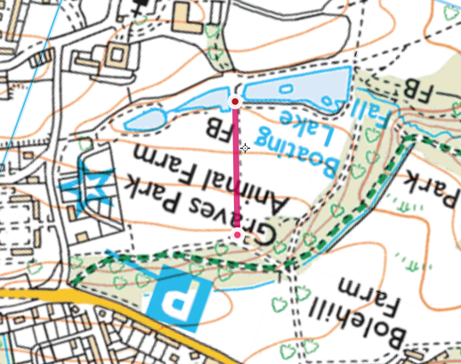
We have already discovered that the black dashed line represents a path. It's worth noting that in this instance a double black dashed line represents a path or a track that would be wide enough to fit a vehicle down. A single dashed line, also represents a path.
It's worth taking a minute to look around and identify different features and see how they are shown on the map. If you look down the hill from where you are stood, you can see a path that is represented on the map by a black dashed line.
As you can see, I have rotated the map around so that if you were to be stood by the toilets, looking down the path across the field the map is now orientated. It's a good idea to orientate the map so that you can get an idea of what you expect is coming up as you travel along the path. For example by orientating the map, I know that as I walk down the path, I will come across two lakes, one on each side of the path. I can also see that it says FB, which mans foot bridge, so i know I will be able to cross the lake.
As we progress through this course, you will need to orientate the map yourself, by rotating your phone as you are walking along, so that it always represents the groun. that you are travelling along.
Now walk down the path until you are stood between the two lakes.
-
Fort St James
-
1. Bienvenue
-
2. Mât
-
3. Entrepôt Général et Magasin de Fourrures
-
4. Cache à Poisson
-
5. Maison des Employès
-
7. Jardin
-
8. Magasin
-
6. La Maison de l'Interprète
-
9. A) Résidence de l'officier
-
9. B) Résidence de l'officier