Start the tour in the green on the north side of Market Street between Fifth and Sixth streets. Look south, toward Independence Hall, which you face in the distance across the broad lawns to the south. The lawns and tourist attractions between where you are standing and Independence Hall are a result of the preservation movement of the 20th century, but their creation, ironically, involved substantial destruction of historic fabric.
The roots of the creation of Independence Park can be found at the turn of the 20th century, in the early preservation movement of that era, including interest in colonial-era history and architecture that grew as part of the City Beautiful Movement.
In 1915, Albert Kelsey and D. Knickerbacker Boyd, two architects enamored of the City Beautiful Movement, proposed clearing out the block between Chestnut and Ludlow Streets in front of Independence Hall. They aimed to open up views of the building, relieve congestion, and create a space that more formally celebrated the building as a monument of American history. Elite Philadelphians, including architects & planners, politicians, and the national Daughters of the American Revolution, continued to advocate for a park (created via clearance) around Independence Hall through the 1920s and ‘30s.
In 1947, the National Park Service collaborated with Philadelphia and Pennsylvania planners and the nonprofit Independence Hall Association to authorize creation of Independence National Historic Park (which was formally established 1956). You are standing in this park now. New buildings, mostly public sector, were built around the Mall during the 1960s-80s to turn this into a dual civic and business space. These structures include the Federal Reserve office, federal court house, and new U.S. Mint to the north of Market; the Rohm & Haas chemical company (now Dow – the modern building on S 6th St); and the renovated old Bourse building (formerly a commodities exchange that was turned into a food court in the 1980s – located on S 5th St) to the south of Market St. The mall would become the main site (along with the Benjamin Franklin Parkway) of the 1976 Bicentennial festivities; since then, it has been the core of Philadelphia’s historic tourism sector and a significant part of the downtown economy.
The park also grew over time. In 1959, the Second Bank of the United States (a neoclassical design by William Strickland, built in 1818-24) was incorporated into the park, which grew to the east to pick up Carpenter’s Hall, the First Bank of the United States, and the Merchants Exchange (another neoclassical Strickland design, completed in 1832-33).
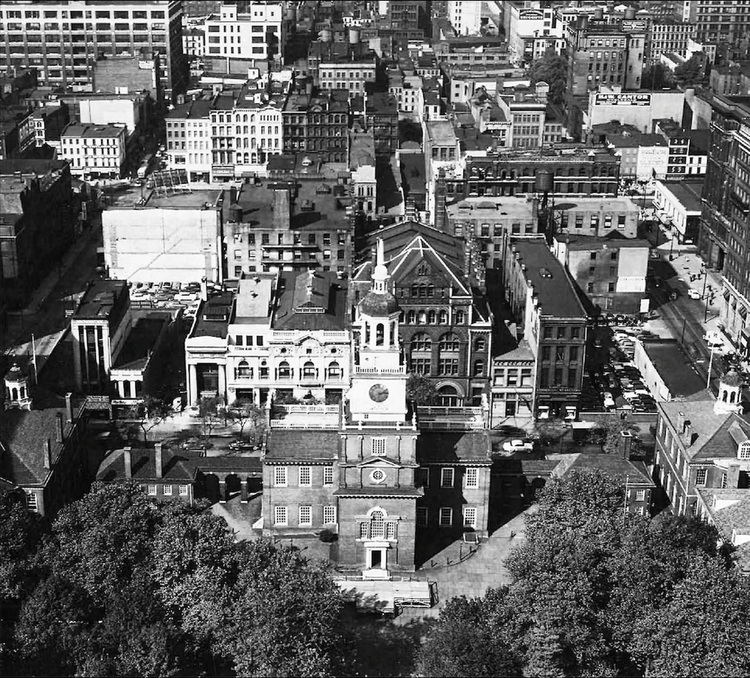
But this new construction and selective preservation came at a cost. During the 1950s, over 100 buildings—including all the buildings on the blocks to the north (the Mall) and almost all the buildings on the blocks to the east of 5th Street (except the few that dated to the 18th century and were part of the city of Ben Franklin, the Revolution, and/or associated with Philadelphia’s history as the national capital) were demolished. The aerial photograph shown here, taken in 1950 looking north from Walnut Street, shows how dense this area once was. In deciding what to retain, planners and preservationists prioritized political history: largely buildings built before 1840. What came down were many industrial and commercial structures that were deemed dilapidated or uneconomical uses of space.
The desire to simply clear space for the preservation of the colonial city also meant the loss of non-dilapidated structures that were not perceived as fitting in. These losses included the Jayne Building (242-244 Chestnut St), a prototypical skyscraper that was the tallest building in Philadelphia when it was completed in 1850, and the Guarantee Trust Company Building (316-320 Chestnut St), completed in 1875 by famed architect Frank Furness.
Later preservation professionals and cultural resource planners have regretted that the park’s design and development only included the stories of Benjamin Franklin, the American Revolution, and the early capital. They wished they had more stories to show and market to a more diverse customer base. While those stories can, of course, still be told, much of the physical fabric that would have helped bring them to material life has been lost.
Image Source: Philadelphia Inquirer